
Oatley Bowling Club Site Masterplan and Plan of Management
Consultation has concluded
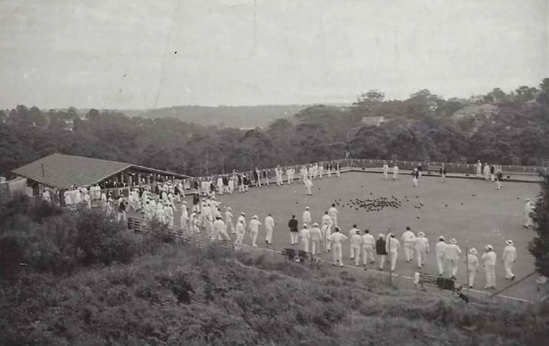
Figure 1 - Oatley Bowling Club
Georges River Council has recently commissioned Cardno (NSW/ACT) Pty Ltd to work with the local community to prepare a masterplan and Plan of Management for the former Oatley Bowling Club site at River Road, Oatley. Council has resolved that the site will be developed for community-based recreation purposes.
In accordance with Council’s Community Engagement Strategy, the design and planning for the land will be carried out in partnership with the local community – the future users of the site.
Site
The land subject to a new Plan of Management and Masterplan is theContinue reading
Figure 1 - Oatley Bowling Club
Georges River Council has recently commissioned Cardno (NSW/ACT) Pty Ltd to work with the local community to prepare a masterplan and Plan of Management for the former Oatley Bowling Club site at River Road, Oatley. Council has resolved that the site will be developed for community-based recreation purposes.
In accordance with Council’s Community Engagement Strategy, the design and planning for the land will be carried out in partnership with the local community – the future users of the site.
Site
The land subject to a new Plan of Management and Masterplan is the former Oatley Bowling Club Site (Lot 100) & Closed Road (Lot 106), 35 River Road, Oatley. The two allotments are shown below:

Figure 2 - Site
Existing documents applying to the land
- The Generic Plan of Management – Natural Areas, adopted 27/02/2008 – applies to Lot 100 in DP.1252069 – which contained the former Oatley Bowling Club site.
- The Myles Dunphy Reserve and Wetland Plan of Management – dated March 2013 – applies to Lot 106 in DP.1252069 – which is the closed road adjacent to, but not part of, the former Oatley Bowling Club site.
Both plans of management can be found on Council’s website.
Community consultation to date
Opportunities for involvement in the design and planning process have included:
- An online survey to provide your opinions on suitable uses of the land for community purposes. The survey closed 6 March 2020.
- A community workshop held 7 March 2020 aimed at providing real community involvement in the development of a plan for the land.
The results of the survey are contained in the updated presentation (see documents section on the right hand side of this web page).
We are at the beginning of the process, with the following tasks to be undertaken:
- Review and analysis
- Community engagement to develop a vision – WE ARE HERE
- Prepare a draft vision
- Preparation of a draft Masterplan
- Preparation of a draft staging plan
- Categorisation of land under the Local Government Act 1993
- Preparation of the draft Plan of Management in accordance with the Local Government Act 1993
- Community engagement and consultation on the Draft Plan of Management and draft Masterplan will involve three drop-in sessions
- Finalisation
Your ideas wanted
At the workshop on 7 March 2020 it was agreed to seek wider community to have opportunity to comment on the three (3) design scenarios which were presented. The scenarios are:
Scenario 1: Conservation (minimal change) |
|
Scenario 2: Middle Ground |
|
Scenario 3: High Activity |
|


Your comments, concerns and ideas are sought by Council in response to the above scenarios. Lodge your feedback with Council by 3 April 2020 by emailing Catherine McMahon on cmcmahon@georgesriver.nsw.gov.au
Council has added a fourth scenario – Your preference – where we invite you to provide your unique ideas. Scenario 4 is below and can be accessed from the document library to the right hand side on this screen. You can print and mark this up and either email cmcmahon@georgesriver.nsw.gov.au, post or drop it in to Council. Please lodge by 3 April 2020.
In developing your own design you may wish to consider the opportunities and constraints of the site. See the document library on the right hand side of the screen for the constraints and opportunities map.

Figure 3 - Scenario 4
Information on the site
The following information is provided to assist you in understanding this project:
What is a Plan of Management?
The Local Government Act 1993 requires Councils to classify public land as Community or Operational. Councils are required to prepare Plans of Management for all public land classified as Community.
The Oatley Bowling Club (OBC) site and Miles Dunphy Reserve are both classified as Community Land.
The former OBC site (Lot 100, DP1252069) and the former road reserve (Lot 106, DP1252069) are both categorised as Natural Area and sub-categorised as Bushland/Watercourse/wetland.
A Plan of Management for community land must identify the following:
(a) the category of the land,
(b) the objectives and performance targets of the plan with respect to the land,
(c) the means by which the council proposes to achieve the plan’s objectives and performance targets,
(d) the manner in which the council proposes to assess its performance with respect to the plan’s objectives and performance targets, and may require the prior approval of the council to the carrying out of any specified activity on the land.
Land Classified as Community is required to be categorised as one or more of the following
- a natural area,
- a sportsground,
- a park,
- an area of cultural significance,
- general community use.
Land that is categorised as a natural area is to be further categorised as one or more of the following
- bushland,
- wetland,
- escarpment,
- watercourse,
- foreshore,
- a category prescribed by the regulations.
Draft Plans of Management must be notified and placed on Public Exhibition for a period not less than 28 days. Public submissions to a draft Plan of Management must be received for a period of not less than 42 days after the Plan is placed on exhibition. A public hearing is required if a draft Plan of Management proposes to categorise or recategorise land. A Masterplan is an overarching spatial layout used to guide the development of land.
In the case of the former Oatley Bowling Club site the public exhibition of the draft Plan of Management and Masterplan will involve two ’drop-in‘ sessions prior to their finalisation and adoption by Council.
Decisions/Actions of Council regarding this project:
- Council resolved on 17 December 2018 to commence the preparation of a new Masterplan for the former Oatley Bowling Club site and a site specific Plan of Management, and remove the site from the Hurstville Generic Plan of Management Natural Areas, adopted February 2008.
Council also resolved to not proceed with the Planning Proposal to re-zone and reclassify the former Oatley Bowling Club site for seniors housing (nursing home) and community facilities and to take all necessary steps to commence the de-contamination of the site (removal of asbestos) to enable its remediation for the purpose of facilitating public access and recreation.
- Council resolved on 25 February 2019 that community garden(s) at the former OBC site be investigated as part of the future community consultation for the Masterplan. This should be undertaken having regard to the known contamination of the site.
Note: The Council resolution dated 17 December 2018 only covers Lot 100 – the former Oatley Bowling Club site. The decision to include Lot 106 was made due to the issue of the stability of the slope along the western and southern boundaries of Lot 100 and its relationship to the former Oatley Bowling Club Site.
Contamination
Council is in the process of engaging a civil contractor for the remediation of the former Oatley Bowling Club site. The site will be remediated through a combination of excavation, consolidation, compaction, capping and offsite disposal to make the site suitable for future recreational and passive use.
Council’s specialist consultants have recommended a risk minimisation approach for the remediation of the site whereby the majority of impacted and contaminated soils are managed on-site by capping the ground surface. This a best practice approach to site remediation which is extensively used to reduce financial and environmental impacts while ensuring a low risk environment to end users of the recreational space. Through this remediation approach the lower section of the site (bordered in red in the concept plan below) will be designated for passive and non-excavation based recreational activities which will be determined through the development of the Plan of Management and associated Masterplan for the site which is currently in progress. Uses will be passive recreation including seating, picnic tables – uses and facilities that do not involve excavation.

Figure 4 - Contamination Concept Plan
Stabilisation works at the site include the construction of gabion wall structures to retain the steep, eroding sections of the site on the southern and western side. These retaining structures were chosen due to the ‘natural’ design elements associated with the use of stone material, while ensuring the structural integrity of the site. The decision to use Gabion structures was based on engineering considerations such as ease of handling and transportation, speed of construction, flexibility (gabions tolerate some movement) and good drainage capability.
The gabions also provide flexibility for future design considerations stemming from the development of the plan of management and master plan for the site, should a recommendation be made for the introduction of a stairway, for example. The gabion structures will also be terraced and provide areas for planting to further naturalise the slope.
The following pictures illustrate two examples of gabion walls.

Figure 5 - Example of gabion wall

Figure 6 - Example of gabion wall
It is Council’s intention to retain as much existing landscaped vegetation as possible on site. Some vegetation however will require removal to ensure appropriate access to enable the certified remediation of the site. Future vegetation planting designs will be developed as part of the Plan of Management and Masterplans currently under development for the site.
The objective of this site remediation work is to ensure the site is safe and structurally sound in order to accommodate the recreational activities identified within the Plan of Management and Masterplan for the site.
Without this remediation work the site would remain unusable and subsequently closed to the public.
The attached plan is an indicative design of the remediated site including zones in which future excavation for Masterplan works can and cannot occur.
Opportunities and constraints – refer to map below

Figure 7 - Constraints and Opportunities
-
CLOSED: This survey has concluded.Consultation has concluded
This survey closed on 6 March 2020.
Share Survey - Oatley Bowling Club Site Masterplan and Plan of Management on Facebook Share Survey - Oatley Bowling Club Site Masterplan and Plan of Management on Twitter Share Survey - Oatley Bowling Club Site Masterplan and Plan of Management on Linkedin Email Survey - Oatley Bowling Club Site Masterplan and Plan of Management link
Signup Banner

Translation
Please note, automatic translations are provided as a guide only and may not be accurate.
Photos

Key Dates
-
23 January 2020
-
06 March 2020
-
19 March 2020
Who's listening
-
CM
Phone 93306260 Email cmcmahon@georgesriver.nsw.gov.au
